Saturday, July 9, 2011

The North Downs

Part of the following was originally penned back in April. My apologies for finishing it so late.
The view from Chartham Downs
Oh, What a Beautiful Morning!  My niece Mia and I went for a ride this morning along the narrow lanes on the edge of the North Downs here in Kent.  Our primary goal was to hear/see a skylark, or if we were very lucky, an early cuckoo.  We were disappointed in that goal but what a wonderful outing we had.  We saw a chiffchaff, magpies, lots of wood pigeons, a goldfinch, a huge and curious fox, a peacock and several pheasants, rooks, etc.  The bluebells were out in force, carpeting the woods. 

Later, we visited Denge wood, although the birds there had gone quiet during the mid-morning.

The next day Mia was again interested in bird-watching and running, although she's way too fast for me!  This time we drove up to Stodmarsh and although we didn't see anything very spectacular, it was another beautiful, quiet morning. Unfortunately, it was again too quiet: no sound of skylarks or cuckoos.  The photo above was taken from one of the hides.  So peaceful as the swan glided from left to right.

The North Downs have, I would say, been a significant factor in my life.  Stretching from Guildford in the West (although, in a sense, the Downs could be said to extend all the way to Salisbury plain) to Dover (and the English Channel) in the East, they form a crescent which brings them quite close in to London.  The Canterbury pilgrims used the downs for several reasons ("The Pilgrims' Way"): firstly for navigation -- it's easier to follow the ridge line of a range of hills.  This must have been especially important in the early days of the pilgrimage (the end of the 12th century) when usage had not yet resulted in easily followed tracks.  Second, they were perhaps a little less likely to be ambushed by footpads since the had the advantage of visibility and height.  Third, the soil (based on chalk) is porous and so wet patches do not develop that would slow passage -- in contrast to the "Wealden" clay just to the South.  As the pilgrims reached the edge of the valley of the Stour (Chilham), they would turn left and leave the downs, passing through Chartham into Canterbury.

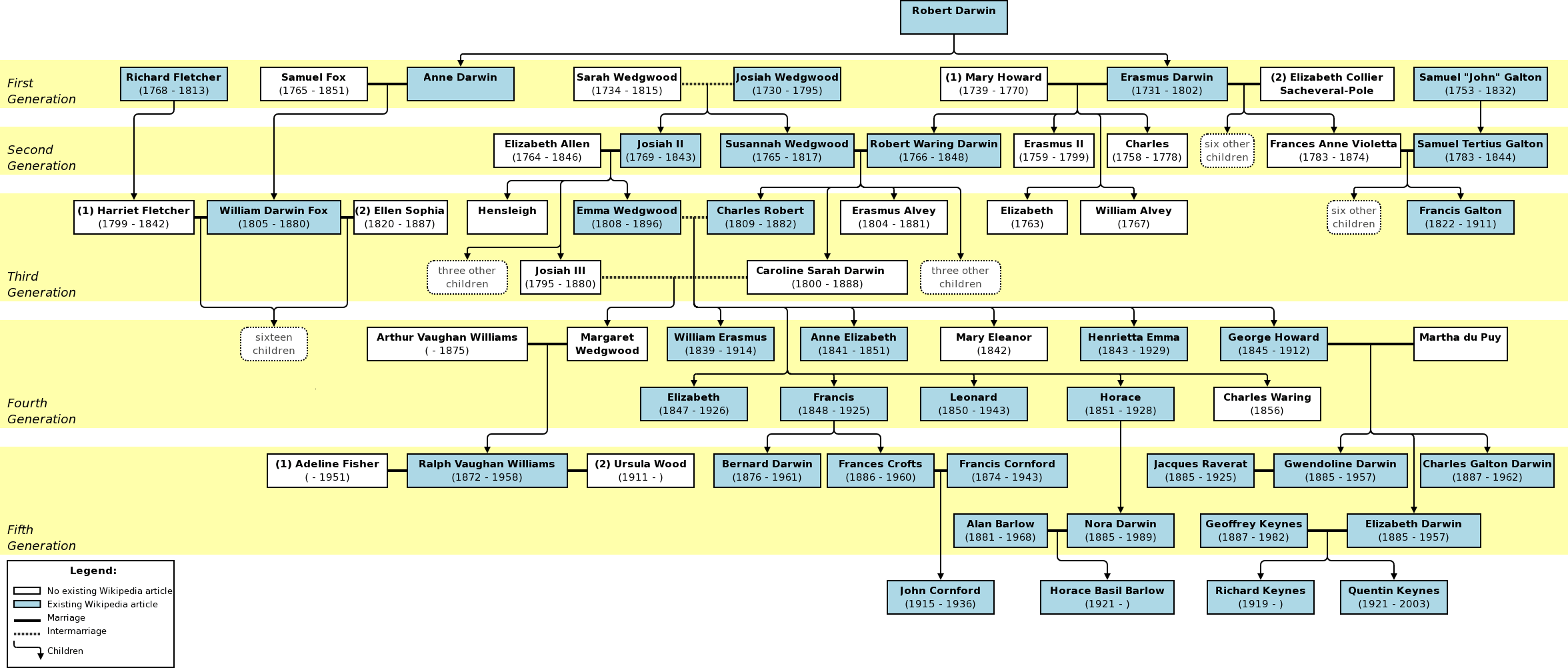
I remember many wonderful day trips from London notably to Box Hill and Leith Hill from which the view was always tremendous.  And two great men, Charles Darwin and Ralph Vaughan Williams were united, not only by the intertwining of their families, but in making their homes on the North slope of the Downs -- Darwin at Downe House in Orpington and Vaughan Williams at Leith Hill Place near Dorking.  I remember these hills too as the domain of the Chalk Hill Blue, a lovely if unassuming butterfly.  Whether or not they are still there, I know not.  Perhaps that should be my next nature quest for the North Downs.

The South Downs too have been if anything an even bigger influence in my youth.  I will tackle them in a future blog.  And I know just where to look for the Chalk Hill Blue in the South Downs :)

Friday, July 8, 2011

A summer of hiking

Looking West from Mt. Abraham towards Saddleback
Another successful hike last Saturday, this time to the summit of Mt. Abraham (Maine) [4037'] with a total of 2950' gain in elevation and about 9 miles round trip.  The majority of the elevation gain was accomplished in the last mile and a quarter of the fire warden's trail so the climb was pretty steep.  See EveryTrail for more details on the climb (with profile).  This time, we only took Puga and Cindy as the "junior" dogs were not really up to it.

We began our training this year with Mt. Wachusett in late April, I think.  That was about 900' elevation gain and only about 3 miles round trip.  We've successively done harder and harder climbs since then (although we gave our legs a rest a couple of weeks ago with Mt. Kearsage South).  I've missed a couple of hikes, but Kim has been on every one.

These days as I'm struggling up the trails to such lofty peaks, I marvel at my sheer insanity seven years ago when I volunteered to go on a two day hike in the Presidential range.  Our plan was to start up the Caps Ridge trail (2720' elevation gain), summit Mt. Jefferson (5716') then go on to bag Mt. Adams before staying overnight at the Madison Springs Hut.  Then on up Mt. Madison the following day.  It was a long time (forever?) since I had done such a demanding hike and, although I had trained assiduously on the stairmaster ahead of time, I had done very little real hiking in preparation.  I must have been mad!

The ascent of Mt. Jefferson, while quite scary at times, went without a hitch.  But by the time we had struggled over to the foot of Mt. Adams, my legs were done.  And I mean done.  So, Kim and I skipped Mt. Adams (sorry!) and made sure we got to the hut in time for dinner.  After dinner, we went on a nature walk and took in the unadulterated night sky.  The following day, we climbed Mt. Madison and had the most unbelievable views.  While the descent might might have seemed easier, my knees could hardly move for the next couple of weeks.

Fast forward to 2011.  Our plan is to conquer Mt. Katahdin later this summer.  It stands at 5268' but with approximately 4000' (ugh!) of elevation gain.  It's one tough mountain by all accounts.

Until this last hike of Mt. Abraham, I was seriously doubting if I could do it.  But now, I know I can and am determined to make all the training worthwhile.  I just hope that the weather is good because I hate hiking on slippery rocks.
Looking North to Sugarloaf and the Bigelow Range beyond